
Know Your Region
What makes Jehanabad special? Explore our district
हिंदी में पढ़ेंJehanabad is our home district in Bihar’s Magadh region, where fertile fields, living traditions and remarkable ancient caves sit close together. It became a separate district on 1 August 1986. Explore its people, rivers, temples and history here, and see how an estimated population differs from a census count.
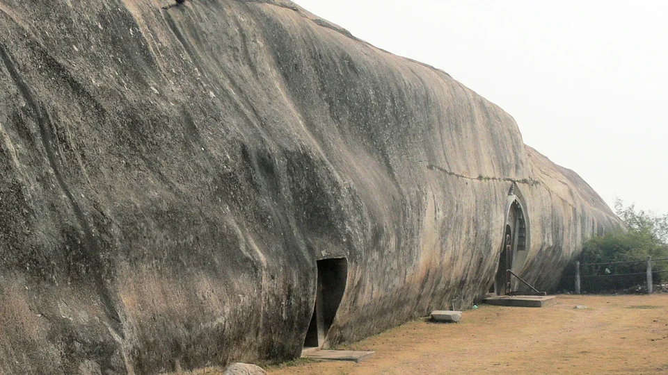

Imagine looking at a smooth cave wall and then at a field of paddy on the journey home. One tells us about craftspeople who worked more than two thousand years ago; the other shows how families earn a living today. Learning about our district connects a history lesson with places we can recognise.
Where is Jehanabad, and what does the landscape look like?
Jehanabad lies south of Patna. Its neighbours are Patna to the north, Gaya to the south, Nalanda to the east and Arwal to the west. The district covers about 931 square kilometres. Most of its land is fertile plain, while the Barabar hills create a striking rocky landmark near Makhdumpur. Summers are generally hot, monsoon rains shape the farming year, and winters are cooler. Check the source
The town of Jehanabad is the district headquarters. A town and a district are different: the district includes many villages and other settlements beyond the town. Population figures on this page refer to the whole district. On a map, try finding the town first, then the hills; notice how a district is much larger than one familiar neighbourhood.
Where is Jehanabad?
Explore the town, nearby settlements and the Barabar–Nagarjuni area. The marker locates the district headquarters area; it is not a district-boundary survey.
How did our district become part of this long history?
This area belongs to the wider historical landscape of Magadha. The Mauryan-period caves show that the region was important long before modern district boundaries existed. A ruler’s territory in ancient times should not be drawn as if it matched today’s Bihar or Jehanabad.
In the colonial administrative system, Jehanabad became a subdivision of Gaya in 1872. It was separated from Gaya as a district on 1 August 1986. Arwal was then created from part of Jehanabad in August 2001, which is why older descriptions may refer to a larger area. These dates help us read an old map without confusing it with the present one. Check the source Check the source
A journey through time
BCE means before the Common Era; CE means Common Era. Ancient dates are approximate, and some periods overlap.
- 3rd century BCE
Mauryan-period caves and inscriptions connect the area with Ashoka, Dasharatha and Ajivika patronage. ↗↗
- Later historical periods
Additional inscriptions and continuing worship show that the sites had lives beyond their first construction. ↗
- 1872
Jehanabad became a subdivision of Gaya. ↗
- 1 August 1986
Jehanabad became a separate district. ↗
- August 2001
Arwal district was created from part of Jehanabad. ↗
Why are Barabar and Nagarjuni Caves so special?
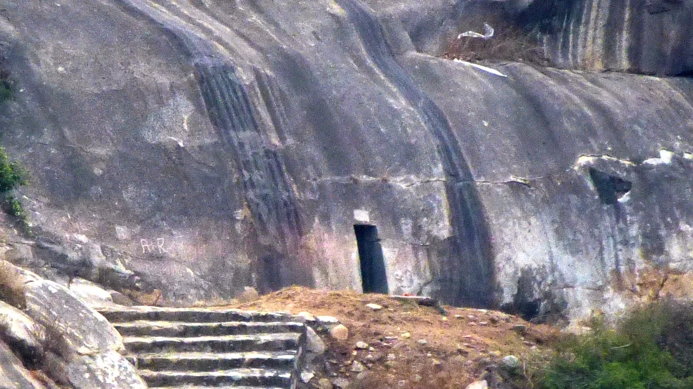
These are some of India’s earliest surviving rock-cut caves, dating to the Mauryan period in the third century BCE—more than two thousand years ago. “Rock-cut” means the spaces were carved into existing rock, rather than built by stacking bricks. Inscriptions connect the caves with royal support for the Ajivikas, an ancient religious community. Check the source
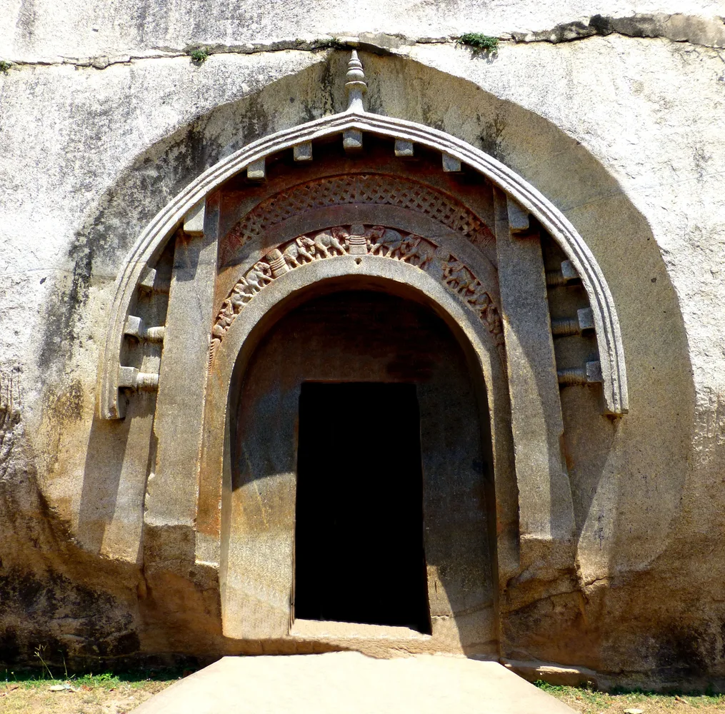
There are four caves in the Barabar group: Sudama, Lomas Rishi, Karan Chaupar and Visva Jhopa, whose names have variant spellings. Lomas Rishi is especially recognisable for its carved arched entrance and elephant decoration. Some interiors have unusually smooth, polished stone surfaces. Ask how a craftsperson might plan a room before removing rock that cannot be put back.
The three Nagarjuni caves form a nearby but distinct group: Gopi or Gopika, Vapiyaka and Vadathika. Their patronage is associated with Dasharatha, Ashoka’s grandson. Do not confuse the seven-cave total with seven caves at Barabar hill alone. Later inscriptions also show that the sites continued to matter after the Mauryan age. Check the source


Which temples and other heritage places can we learn about?
Siddheshwar Nath Temple, dedicated to Shiva, stands in the Barabar hill area and is associated with Shravan pilgrimage. It belongs to the living religious landscape around the caves; its history should not be assumed to be identical to the date of every cave. We have not assigned an uncertain construction year to it.
The district’s official gallery also records Vishnu Temple at Kako and Kako’s Surya Mandir. At Kako, the shrine of Hazrat Bibi Kamal represents the region’s Sufi heritage. People visit these places for different reasons—worship, family tradition, local history or architecture. We can learn respectfully without turning a faith tradition into a scientific claim. Check the source Check the source
What do population and literacy figures actually tell us?
The latest estimate displayed here is for October 2026, not a new census. We calculated it by keeping Jehanabad’s share of Bihar’s population the same as in 2011, then applying Bihar’s official 2026 state projection. It is a simple learning estimate: migration, births and deaths may make the real district total different. The calculation and sources are available beside the number. Check the source
The final 2011 Census recorded 11,25,313 people and a 66.80% literacy rate among people aged seven and above. That literacy percentage belongs to 2011; it is not an estimate of today’s literacy. Literacy in the census means being able to read and write with understanding. The dates matter as much as the numbers. Check the source
How is the district organised?
Jehanabad has one subdivision and seven administrative blocks: Jehanabad, Makhdumpur, Ghosi, Hulasganj, Ratni Faridpur, Modanganj and Kako. Blocks help organise public administration across groups of settlements. A child’s village, block and district are different levels of location, much as a classroom belongs inside a school. Check the source
Try asking an adult which block your village or family home belongs to. For a school project, mark the block name without publishing a child’s exact home address. Administrative details can change, so official district sources are a useful place to check them.
Which rivers and crops shape everyday life?
The district handbook lists Phalgu, Dardha and Yamuna among the main rivers. Local spellings may differ; this Yamuna is a local river, not the large Yamuna associated with Delhi. Rivers, rainfall, soils and irrigation together help explain the pattern of fields and settlements.
Paddy, wheat, pulses such as gram and lentils, and mustard are important crops; the district overview also names maize. Farming is a major part of local livelihoods, alongside markets, services, transport and other work. Avoid the mistaken idea that every family does the same job. A useful classroom activity is comparing a monsoon-season crop with one grown in the cooler months. Check the source Check the source
What makes the culture familiar and distinctive?
Magahi is part of everyday life in the Magadh region; Hindi and Urdu are also heard and used. Families may move between languages depending on whom they are speaking with. Listening to a grandparent’s story in their preferred language is one way to learn local words and memories. Check the source
Chhath, Holi, Diwali, Durga Puja, Eid and local religious gatherings bring different communities together in different ways. Chhath’s songs, preparation and offerings to the Sun are an important part of Bihar’s cultural life. Family practices vary, so one household’s custom should not be described as a rule for everyone. Seasonal food, folk songs and shared work also carry culture beyond festival days. Check the source
Which personalities have a connection with Jehanabad?
Samprada Singh, who founded Alkem Laboratories, was born in Okri village in the district. His brother Basudeo N. Singh is the company’s co-founder. Their story gives students a local connection to enterprise and the pharmaceutical industry. These are documented associations, rather than a ranking of the district’s “greatest” people. Check the source
Ashoka and Dasharatha are connected through the caves’ royal patronage; that does not mean they were born in Jehanabad. Farmers, craftspeople, teachers, writers and community workers also shape a place, even when their names do not appear in national history books. Ask whose work your class could document with permission.
How can we explore and protect our heritage?
Begin with a map and the official site information. For a family or school visit, let adults check access, weather and arrangements. Around caves and temples, follow the site’s rules, respect worshippers and avoid writing on, scratching or removing anything from stone surfaces.
Carry a notebook rather than trying to remember every date. Sketch an arch, note a river name or write one question for a guide. Afterwards, separate what you observed, what a source confirms and what someone shared as a local story. That habit helps young learners enjoy their region while becoming careful historians.
8 Did you know?
The seven famous caves belong to two groups: four at Barabar and three at Nagarjuni.
↗Lomas Rishi’s carved arch and elephant decoration are a memorable example of early stone architecture.
↗Polished cave interiors show the skill of craftspeople working with hard stone.
↗The local Yamuna river should not be confused with the large river associated with Delhi.
↗Patna, Gaya, Nalanda and Arwal are the district’s neighbours.
↗Okri village connects Jehanabad with Alkem founder Samprada Singh.
↗
Pause, think, discover
Try 10 GK questions
Think of an answer first, then open each question to check. No score or personal information is stored.
Which state is Jehanabad in?
When did Jehanabad become a district?
Which district was Jehanabad separated from in 1986?
How many administrative blocks are listed for Jehanabad?
In which block area are Barabar Caves located?
How are the seven caves divided between the two hills?
Which cave is known for its carved arched entrance?
Name two rivers listed in the district handbook.
Which place is associated with Bibi Kamal’s shrine?
Where can we check the details?
- REG-S01: District Census Handbook, Jehanabad, Part B
- REG-S02: District Census Handbook, Jehanabad, Part A
- REG-S03: Population Projections for India and States 2011–2036
- REG-S04: About District
- REG-S05: Subdivision & Blocks
- REG-S06: About Arwal district
- REG-S07: Centrally protected monuments: Patna Circle
- REG-S08: About Barabar Caves
- REG-S09: Vishnu Temple, Kako
- REG-S10: Hazrat Bibi Kamal Ka Makbara
- REG-S11: Founders’ Story
- REG-S22: Linguistic Survey of India: Bihar
- REG-S26: Tourism Department: Bihar overview
What can we explore next?
Want to check the sources?
These notes explain what was checked for the article. The date is an information check, not a publication date.
- REG-S01: District Census Handbook, Jehanabad, Part B
Census of India
Where to look: Printed pp. 15–16 (PDF pp. 24–25): final 2011 statistics
How it was checked: Official text retrieved
Final census totals are used instead of inconsistent district-web summaries. Literacy is for age 7+, not a 2026 rate.
- REG-S02: District Census Handbook, Jehanabad, Part A
Census of India
Where to look: Printed pp. 25–26: physical features, rivers and crops
How it was checked: Official text retrieved
Geography and historical context; dated counts of facilities are not treated as current.
- REG-S03: Population Projections for India and States 2011–2036
National Commission on Population, MoHFW
Where to look: Table 14, printed p. 123, PDF p. 127: Bihar persons, 1 October 2026, thousands
How it was checked: Official text retrieved
133,289 thousand = 133,289,000. This is a state projection, not a new census or official district estimate. Table and units visually checked.
- REG-S04: About District
Jehanabad District Administration
Where to look: Formation on 1 August 1986; subdivision from 1872; crops
How it was checked: Official text retrieved
Web demographic totals conflict with final Census tables; they are not copied. The naming legend and sweeping no-industry claim are not presented as established history.
- REG-S05: Subdivision & Blocks
Jehanabad District Administration
Where to look: One subdivision and seven named blocks
How it was checked: Official text retrieved
Current page checked on 21 October 2026; administrative arrangements can change.
- REG-S06: About Arwal district
Arwal District Administration
Where to look: Arwal created from Jehanabad in August 2001
How it was checked: Official text retrieved
Use month/year; earlier district boundaries differ from the present area.
- REG-S07: Centrally protected monuments: Patna Circle
Archaeological Survey of India
Where to look: Entries 17–25: Jehanabad caves and sculptures; entries 2 and 39: Vikramshila and Nalanda
How it was checked: Official text retrieved
Use architectural descriptions and named sites. Avoid presenting disputed later inscription dates as exact.
- REG-S08: About Barabar Caves
Bihar Government Barabar Cave Tourism
Where to look: Four Barabar and three Nagarjuni caves; Mauryan patrons; Siddheshwar Nath temple
How it was checked: Official indexed excerpt; direct download unavailable
Official indexed text checked; direct retrieval timed out. Unsupported temple dating and visitor totals are omitted.
- REG-S09: Vishnu Temple, Kako
Jehanabad District Administration
Where to look: Official photo-gallery labels: Vishnu Temple and Kako Surya Mandir
How it was checked: Official text retrieved
Confirms local sites, not their precise construction dates. Images are not reused without a licence.
- REG-S10: Hazrat Bibi Kamal Ka Makbara
Bihar Tourism
Where to look: Kako shrine and Sufi heritage
How it was checked: Official text retrieved
Religious traditions are described respectfully, not as medical evidence or unverified first-in-India claims.
- REG-S11: Founders’ Story
Alkem Laboratories
Where to look: Samprada Singh born in Okri; Basudeo N. Singh co-founder
How it was checked: Official text retrieved
Company biographical account. Only the local association and founding roles are used; promotional superlatives are omitted.
- REG-S22: Linguistic Survey of India: Bihar
Census of India
Where to look: Discussion of Bhojpuri, Magahi and Maithili
How it was checked: Official indexed excerpt
Regional languages are not reduced to one uniform Bihari language. No current speaker percentages are claimed.
- REG-S26: Tourism Department: Bihar overview
Government of Bihar
Where to look: Neighbours, cultural regions, crops, rivers, festivals and Valmiki tourism
How it was checked: Official text retrieved
General overview only; no current opening hours, prices or travel guarantees.
Next planned check: